
- DCNR aerial reconnaissance photo of the 16 Mile Fire (left) and Beartown Fire (right) taken mid-afternoon of the first day of the incident. Photo:DCNR
The day started no different that the several before it. A high pressure system had settled in over Northeastern Pennsylvania during late April that helped enhance the chance of a rapidly spreading wildfire. Smaller blazes had been breaking out in Pike County for a week or so already. It was spring fire season and this was expected. Up to that morning, there had been twenty-four fires Bureau of Forestry firefighters responded to between Pike and Monroe since the end of February. Over the preceding days the fire danger level had steadily increased from “Moderate” to “High” and then “Very High.” The last, an uncommon rating in the area, but not unprecedented. Corresponding to the rise in danger, the local wildland fire crews heightened their readiness level as well. What started off as four pillars of white smoke in the morning of May 20, rapidly intensified into two separate conflagrations. The columns changed to clouds and by 3:00pm a banner of smoke easily seen over 30 miles away waved over the ridgeline. By the next morning the wind and weather shifted and much of Pike Country smelled like a smokehouse. Welcome to the Cresco Complex Fire.

- National Park Service firefighters from the Delaware Water Gap National Recreation Area were some of the first federal resources on the fire. Photo Jon Castimore/NPS
The final weeks of April and the first week of May were quite busy for me. In addition to the nearly unprecedented Cresco Complex Fire that was incinerating the Monroe-Pike County border, DCNR and volunteer fire crews spent a lot of time battling other brush fires that were popping up around the area. While I did spend some time supporting the efforts waging war against the big fire, most of my time was spent on the initial attack team in Pike County that was occupied with preventing other fires from getting out of hand. These ranged from small acreage field fires to an 80 acre blaze on PA State Game Lands.
When the radio chatter about the smoke sightings that would become the Beartown and 16-Mile fires started I was out checking deer exclosure fences near Greentown. I normally don’t take fire equipment with me when I head out to the regeneration plots, but on that day something in my brain said take a fire tool and a water bladder in the event I either find something or my UTV inadvertently catches something on fire. Before I could even finish my task for the morning I was called back to the station and was reassigned to fire patrol. Our bulldozer operator had been reassigned from the Pike County patrol to the quickly growing fire in Monroe County. That move alone indicated to me that what was going on to the south was getting big, fast.
I fully knew we weren’t going to respond to what was going on in Monroe. Already the DCNR units there as well as local volunteer units and a group of federal firefighters enroute back to the Delaware Water Gap from a training were engaged, as were a number of aircraft. Myself; my usual partner, Dave; and our Fire Supervisor Bill were sitting tight in the event we were needed in Pike. We didn’t wait long for a call. By 3:00pm we were rolling to Westfall Township to assist local units there. On the way to help them we got our first look at what was going on with the big fire. As we exited the interstate at Matamoras a look west toward the ridge 28 miles away showed the massive smoke plume rising from the 16-Mile fire. By 5:00pm we were heading back to our station and the cloud had grown larger. While a few of our station’s crew headed to the big fire for a night shift, we knew we’d be back in Pike the next day.

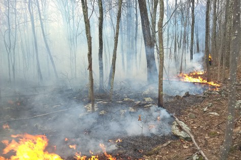
- Several attempts were made to backburn areas of the forest in order to stop the advance of the fire but many were unsuccessful as the speed of the fire’s advance was extremely rapid. Photo: Dan Buttaro/DCNR
Dave and I intercepted a small fire sparked by Thursday’s winds that downed a power line just south of Promised Land and later that afternoon we found ourselves in Milford on another blaze that burned up the side of a hill behind the pharmacy on Route 6. Meanwhile the monster grew steadily to 2621 acres and more and more resources from around the state were pouring in to contain it.
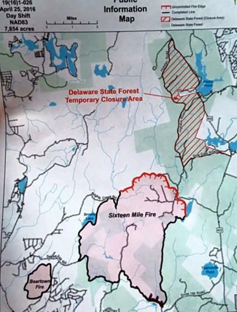
- DCNR map showing the size and containment efforts of the two fires in the Cresco Complex. This map is from (or about) April 25. Heavy black lines around the fire areas represent containment and red boundaries show the active fire front.
Overnight the 16-Mile fire expanded to almost 3600 acres. When we arrived at our station Friday morning the smell of smoke filled the air. Wind and inversion pushed the smoke north and it lingered over northern Pike county much of the day. Dave and I were headed to Milford to do a day-after check on the fire we helped extinguish the afternoon before when we were called to a fire in Shohola and later that day we ended up on the game lands for another blaze that lasted until 8:00pm. Our friends to the south were suffering from the same forces of weather. By the time we finished up near Shohola Lake, the 16-Mile fire had grown to 5029 acres.
- Elsewhere in Pike and Monroe counties, smaller fires broke out on a daily basis. DCNR crews with Volunteer Fire Departments tackled this fire on State Game Lands near Shohola Lake utilizing a combination of tactics that included everything from retardant drops by aircraft to gas powered leaf blowers used to remove light fuels from the path of the fire.
I was off the day shift on Saturday. I knew I was going in for overnight duty on the big fire but I decided to take a drive around the fire area that afternoon. Things were relatively quiet. Smoke was hard to see and signs of firefighting activity were difficult to detect. Everyone was out in the woods far from the roads. However the front was still moving northeasterly towards the cabins around the Ludleyville and Pine Flats area in Porter Township.
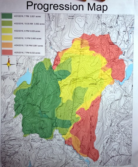
- DCNR map showing the daily progression of the fire’s growth.
When I came in that evening at 8:00pm I was told I was going with one of our engines to provide structure protection to a camp near Canadensis. Some of the area had already been burned over but there was still a threat now coming from another direction. Through the night we kept a vigil and watched the fire out in the darkness. The main line heading toward us moved little but over the ridge we could see the glow emitted by the backburn that was taking place in an effort to stifle the front moving towards Pine Flats. Less than an additional 300 acres burned by the end of Sunday and by that time many felt good progress was being made.
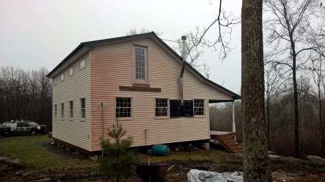
- PA Bureau of Forestry Type 6 Engines such as these were used in a variety of roles ranging from initial attack to structure protection. Hunting camps such as this one with good buffer zones free of fuels were easily defended. Note the burned area in the foreground.
Countywide burn bans helped stave off smaller fires on Monday and things remained relatively quiet outside of what was going on just west of Pine Flats. While many bulldozer lines were cut through the area fires jumped the overturned earth here and there. Sometimes the fire crept along the ground and at other occasions it would dance from tree to tree. By 7:00pm that night the expanse of the damage had blossomed to 8032 acres and consumed five cabins and six outbuildings.

- Several cabins such as this were unfortunately consumed by the fast moving fire and reduced to nothing more than a foundation, chimney, and ash.
Rain finally arrived Monday evening. Coupled with the large amounts of fire retardant and dozer lines spread through the forest, the fire was for the most part now contained. For the next few days much of the effort switched to mopping up and initiating the rehabilitation of the areas damaged by the machinery.
Entering “the black” or burned areas was something near surreal. Some cabins that had ample clear space around them were literally unscathed while other structures were reduced to ash and piles of almost unidentifiable objects. In some cases just a chimney was all that remained. Here and there the orangish-pink residue left from the fire retardant drops could be seen on woodpiles and buildings. Where the fire crawled along the ground, the forest floor was charred and where it moved through the trees more so, bark and limbs were scarred.
- Airtanker drops were close enough to some structures that retardant hit the siding leaving behind an orangeish-pink residue.
Much of what burned was an area that had been devastated by Gypsy Moth nearly a decade ago. Corpses of trees stood as if undead for years. Dry and rotted they provided ample fuel for the fire and the same thick understory that hampered police efforts in the manhunt for Eric Frein two years ago added to the fuel mix. While the blaze has been ruled an arson, a naturally occurring fire under the same conditions very well may have yielded similar results. I will keep my own suspicions as to why the blazes were started but I will say that I believe even the arsonist probably got more than he or she was bargaining on when they set the initial fires.
All Photos © Bill Deaton 2016 unless otherwise noted.
