Tag Archives: Pennsylvania Waterfalls

Falls in the Forest

Choke Creek Falls in the Pinchot (formerly Lackawanna) State Forest

Sometime about seven years or so ago, the details escape me now to the circumstances surrounding the original voyage, accompanied by one of my usual adventuring companions, Lee Shaffer of Avoca, I visited Choke Creek Falls for the first time. Since then I had always wanted to return to explore the area some more and get better acquainted with the lay of the land so I could do some more solo trips here. That never happened until just a few days ago. Of course I couldn’t remember the directions once the road ended so again, Lee volunteered to show me the way. So with cameras and fishing rods, off we went.

Getting There

It takes about a half-an-hour to get to the trailhead from the intersection of PA-435 and Clifton Beach Rd between Daleville and Gouldsboro. Starting from there, travel 4.9 miles on Clifton Beach Rd, and another 0.9 on the same road once it turns into River Rd.

Make a right on to Pine Grove Rd and take that 1.5 miles to a T-intersection, then turn right on to Bear Lake Rd. and travel about 0.1 mile to Tannery Rd, an improved dirt/gravel forest road. Turn left on to Tannery Rd. and continue 1.2 miles to an opening/intersection with Phelps Rd where you make a very sharp left. Phleps Rd. winds through the forest and after 2.2 miles comes to a black and yellow gate at a sharp right turn. Park here but do not block the gate. This is the trailhead. It is not marked.

Recent logging in the area is evident and heavy equipment might be present if you visit in the near future, so use care. Travel through the gate and continue for about 0.3 mile to a log landing. Bear right here and walk another .25 mile to a log bridge. Cross the bridge and immediately turn left onto a footpath. This trail follows the creek along the north bank for about .15 mile to where the falls are located.

What To Do

Most of the trail there is within the boundary of the Lackawanna State Forest, but the final part of the route and the creek itself lie in PA State Game lands #91. There were no “No Camping” signs seen on the Bureau of Forestry property so one can assume that the DCNR Primitive Camping Rules apply here. However, camping is not permitted on PA State Game Lands, nonetheless signs of overnight use are readily visible at the falls.

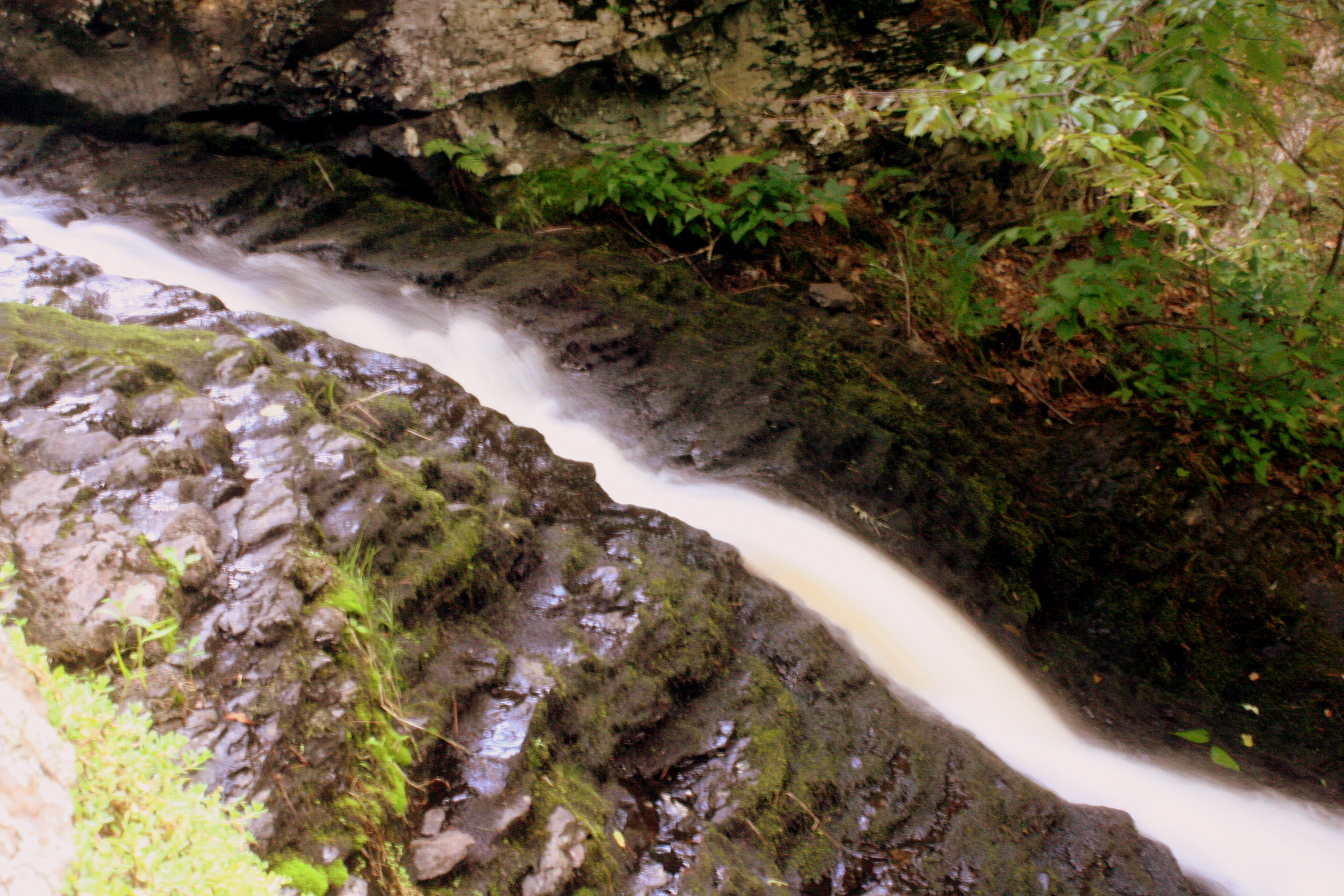
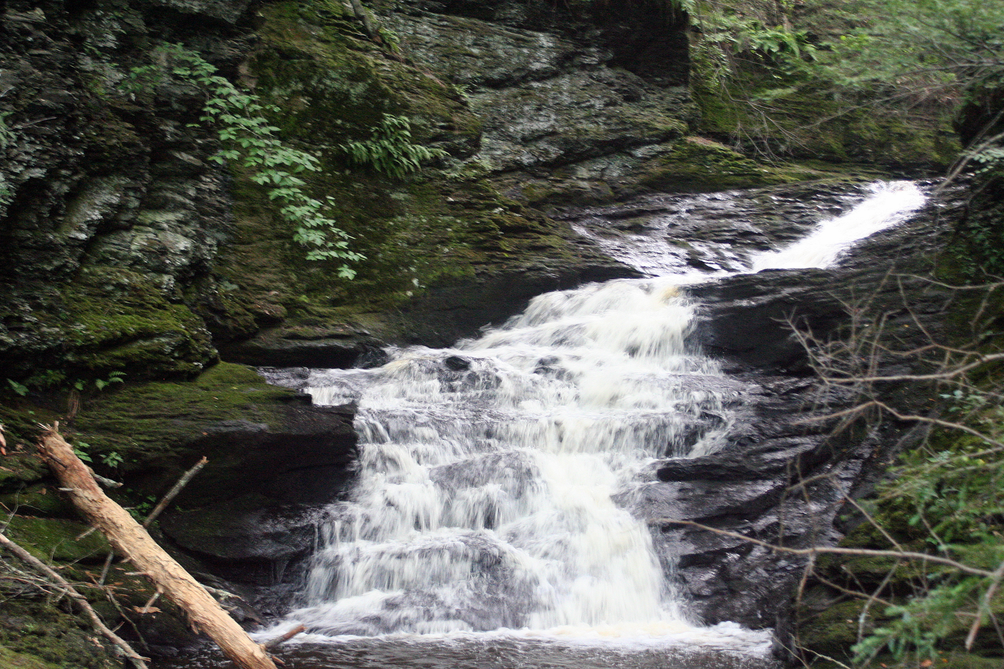
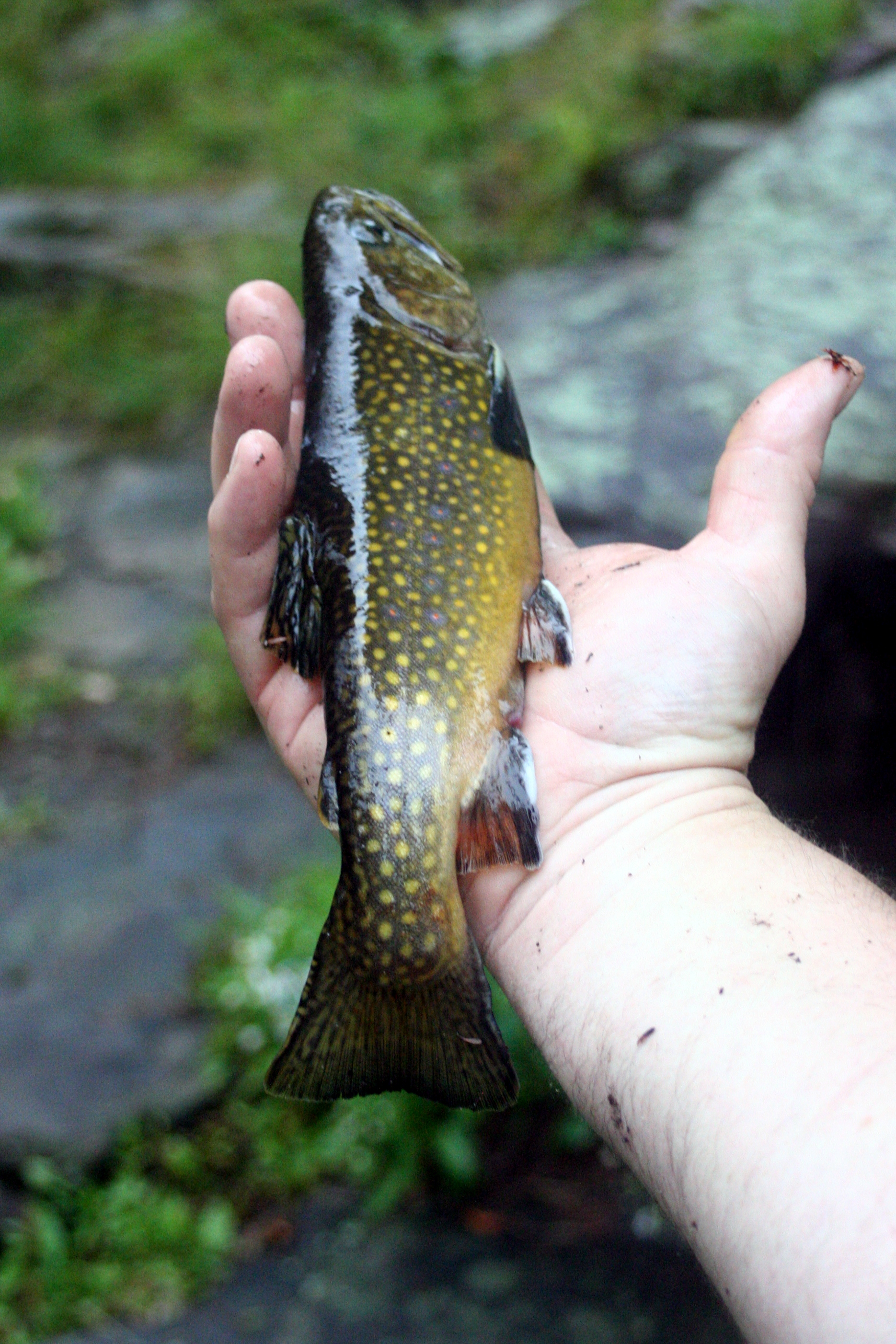
Fishing was good. In less than an hour Lee hooked at least four Brook Trout using mealworms on a spinner rod from the cliffs below the main falls. There’s a natural pool, below the main cascade and another larger “man-enhanced” pool below the short chute. He pulled fish out of both spots with relative ease.

I busied myself with photography. There’s a number of spots to shoot the falls from but if you want the best shots you’ll have to get wet. That means wading out into the lower pool to take a head-on shot of the waterfalls. Most point-and-shoot and phone cameras will get you a nice enough photo of the falls but you’ll want a tripod if you wish to do some more serious photography since there aren’t a lot of natural things to prop a SLR camera on for technical shots.

Taking a dip is also another option. On a hot, muggy afternoon, a swim in the cool creek would offer some sweet relief to the dog days of summer. There is obvious signs that this is a commonly used swimming hole. Several ropes hang from a tree and a series of boards have been hammered into the same tree forming a makeshift ladder for either accessing the swing or for jumping off of.

Choke Creek Native Brook Trout. Caught and Released.

Take Care

As typical with many of our trips into the local woods, we hauled out someone else’s trash. While the area was not overly covered in litter, we did get rid of some beer bottles, monofilament, a few cans, and a couple of bait containers. Cigarette butts, which people seem to forget do not biodegrade, tend to be the most commonly discarded thing there. So of you visit, do your part and haul out your trash, please. It’s a beautiful area that with some TLC can remain that way for a long time.

Indian Ladders Falls

Top Falls and Pool
First cascade and pool. Average pool depth is about 5′ and perfect for a swim.

The Delaware Water Gap National Recreation Area boasts a bevy of scenic attractions, waterfalls being among the chief draws for locals and tourists alike. Most of these picturesque cascades, such as Dingman’s Falls, Raymondskill Falls, and Childs’ Park are surrounded by walkways and viewing decks. While these features make viewing the waterfalls somewhat safer for the casual visitor and also concentrate the environmental impact made by hikers, at the same time they create a buffer that restricts adventurers from getting “Up close and personal” with the raw power of the churning water. However, if you are the type of outdoorsman that prefers to “experience” nature rather than just “enjoying” it, there are several, lesser known waterfalls where access is relatively unlimited. One such location are the Indian Ladders Falls.

Sketchy Sources

Obtaining accurate information about these falls proved to be the first challenge. Carl Oplinger’s “The Poconos” guidebook fails to list these falls and instead addresses a like-named series of falls located on the Skytop Resort property just over the Pike County line in Monroe County; Scott Brown’s “Pennsylvania Waterfalls” mentions four waterfalls and places them off Dickinson Rd, not Emory Rd (which also has various spellings depending on the source); and the Park Service notes this is also the Hornbeck Creek Trail and that there are two waterfalls, but then goes on to explain the “Ladders” are a series of falls and another waterfall (cited as “Tumbling Waters” in Brown’s guidebook) is located along the same trail. Confused? To add another layer of befuddlement to this quest, the Park Service has closed a section of the trail between the two series of falls; removed the online map; and has a link to directions that only show the access point off US-209 for the lower falls, not the Ladders.

Brown’s book, the mislabeled road aside, proved to be the most accurate source as it has a fairly easy-to-decipher map. Get oneself to the Pocono Environmental Education Center on Emery (their spelling) Rd. and leaving the PEEC parking lot, turn left and travel approximately 1.9 miles until the road crosses Hornbeck Creek. Pull-off lots are located on either side of the small bridge and the trails meander downstream from the road.

Hitting the Trail

Unlike many other natural attractions, no signage exists here to welcome you or warn you. There’s no informational kiosk, posted map, or painted trees to even guide you through the woods. A fairly well worn trail is easy to follow but smaller paths, here and there, lead wanderers to various spots along the creek where one can walk right out on to the cliffs and crags that bound the rushing water.

The first spectacle encountered on the downstream trek was a slide where a vein of water flowed for several yards before beginning an 18-20 foot plummet to a plunge pool. Accessing the slide is relatively easy if you’ve hugged the stream the entire way, getting down to the base of the falls takes a bit more effort as there’s no clear cut trail on one side of the stream.

Top chute.

Loose earth and crumbling rock make for a sketchy but short hike to a head-on view of the falls, uncluttered by boardwalks and split-rail fencing. On the opposite bank a more well-worn trail appears to offer an easier access way to the same spot. The pool depth averaged around five feet and one can literally wade right up to where the falling water reunites with the creek.

Continuing downstream, next a small chute cuts through the rock for about six feet and then after a short, flat run, drops abruptly for another 20-25 feet over a cascade. One can get into the gorge in between the chute and cascade and take in the sound of the water and the shapes it has created over the past 15,000 years or so. Sand that was deposited here millions of years ago sat undisturbed until the last ice age. When the glaciers receded the water flowed and began to make light work of the brittle rock. Eons of erosion are easy to observe from this spot.

Gorge
Inside the gorge.

Finally, the trail drops to the base of the fourth falls detailed in the guidebook, another cascade. This one is about 40 feet high and has a less inviting pool at the base due to the swifter current and slippery rocks. However the side trail to the base puts one in a great position to view the falls head-on.

Third Fall
Final Falls

Below this the trail seemed sketchy. There were no “Closed Trail” signs indicating the restrictions set by the Park Service, but it’s possible that the closed section of trail is further along. Regardless, a nice hike that allows one to experience waterfalls without man-made interference awaits for those that desire it.

Root
Eroded and exposed root in the gorge.