Indian Ladders Falls

Top Falls and Pool
First cascade and pool. Average pool depth is about 5′ and perfect for a swim.

The Delaware Water Gap National Recreation Area boasts a bevy of scenic attractions, waterfalls being among the chief draws for locals and tourists alike. Most of these picturesque cascades, such as Dingman’s Falls, Raymondskill Falls, and Childs’ Park are surrounded by walkways and viewing decks. While these features make viewing the waterfalls somewhat safer for the casual visitor and also concentrate the environmental impact made by hikers, at the same time they create a buffer that restricts adventurers from getting “Up close and personal” with the raw power of the churning water. However, if you are the type of outdoorsman that prefers to “experience” nature rather than just “enjoying” it, there are several, lesser known waterfalls where access is relatively unlimited. One such location are the Indian Ladders Falls.

Sketchy Sources

Obtaining accurate information about these falls proved to be the first challenge. Carl Oplinger’s “The Poconos” guidebook fails to list these falls and instead addresses a like-named series of falls located on the Skytop Resort property just over the Pike County line in Monroe County; Scott Brown’s “Pennsylvania Waterfalls” mentions four waterfalls and places them off Dickinson Rd, not Emory Rd (which also has various spellings depending on the source); and the Park Service notes this is also the Hornbeck Creek Trail and that there are two waterfalls, but then goes on to explain the “Ladders” are a series of falls and another waterfall (cited as “Tumbling Waters” in Brown’s guidebook) is located along the same trail. Confused? To add another layer of befuddlement to this quest, the Park Service has closed a section of the trail between the two series of falls; removed the online map; and has a link to directions that only show the access point off US-209 for the lower falls, not the Ladders.

Brown’s book, the mislabeled road aside, proved to be the most accurate source as it has a fairly easy-to-decipher map. Get oneself to the Pocono Environmental Education Center on Emery (their spelling) Rd. and leaving the PEEC parking lot, turn left and travel approximately 1.9 miles until the road crosses Hornbeck Creek. Pull-off lots are located on either side of the small bridge and the trails meander downstream from the road.

Hitting the Trail

Unlike many other natural attractions, no signage exists here to welcome you or warn you. There’s no informational kiosk, posted map, or painted trees to even guide you through the woods. A fairly well worn trail is easy to follow but smaller paths, here and there, lead wanderers to various spots along the creek where one can walk right out on to the cliffs and crags that bound the rushing water.

The first spectacle encountered on the downstream trek was a slide where a vein of water flowed for several yards before beginning an 18-20 foot plummet to a plunge pool. Accessing the slide is relatively easy if you’ve hugged the stream the entire way, getting down to the base of the falls takes a bit more effort as there’s no clear cut trail on one side of the stream.

Top chute.

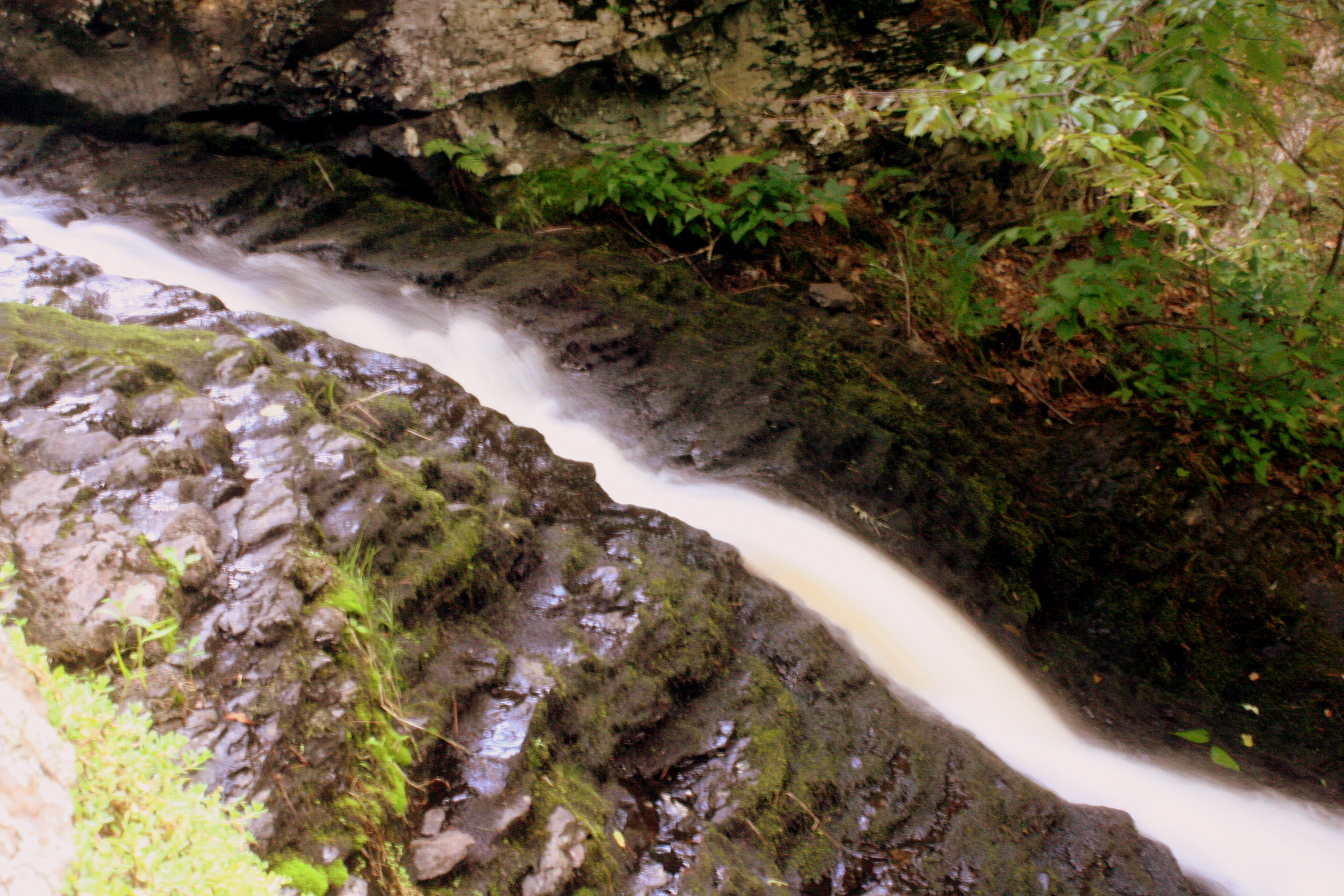
Loose earth and crumbling rock make for a sketchy but short hike to a head-on view of the falls, uncluttered by boardwalks and split-rail fencing. On the opposite bank a more well-worn trail appears to offer an easier access way to the same spot. The pool depth averaged around five feet and one can literally wade right up to where the falling water reunites with the creek.

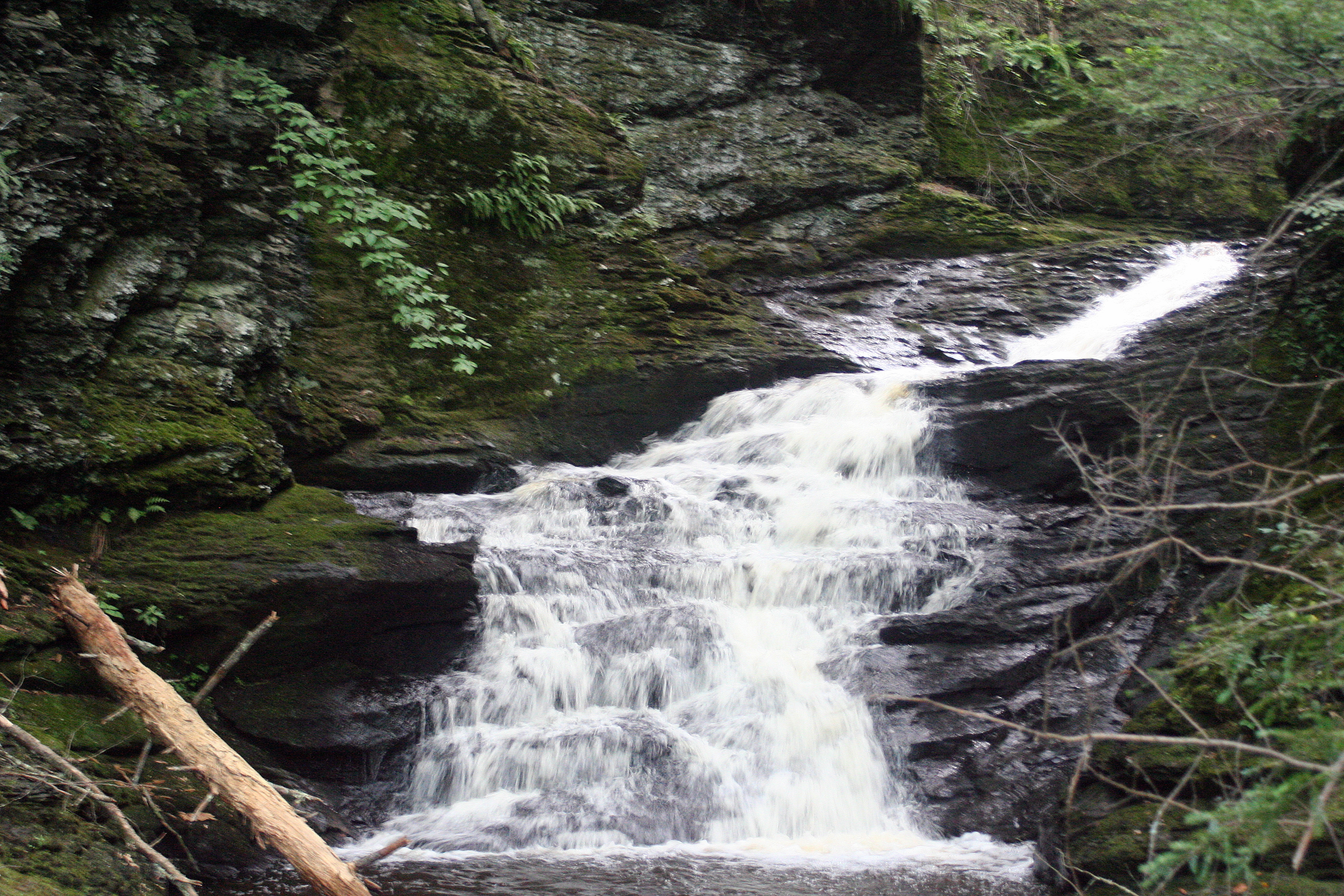
Continuing downstream, next a small chute cuts through the rock for about six feet and then after a short, flat run, drops abruptly for another 20-25 feet over a cascade. One can get into the gorge in between the chute and cascade and take in the sound of the water and the shapes it has created over the past 15,000 years or so. Sand that was deposited here millions of years ago sat undisturbed until the last ice age. When the glaciers receded the water flowed and began to make light work of the brittle rock. Eons of erosion are easy to observe from this spot.

Gorge
Inside the gorge.

Finally, the trail drops to the base of the fourth falls detailed in the guidebook, another cascade. This one is about 40 feet high and has a less inviting pool at the base due to the swifter current and slippery rocks. However the side trail to the base puts one in a great position to view the falls head-on.

Third Fall
Final Falls

Below this the trail seemed sketchy. There were no “Closed Trail” signs indicating the restrictions set by the Park Service, but it’s possible that the closed section of trail is further along. Regardless, a nice hike that allows one to experience waterfalls without man-made interference awaits for those that desire it.

Root
Eroded and exposed root in the gorge.

Tusten Mountain Trail: Upper Delaware Scenic & Recreational River

 
Looking out from the Tusten Mountain vista.

Most of the Delaware River from northeast Pennsylvania border with New York to just south of the borough of Delaware Water Gap falls under the jurisdiction of the National Park Service. The Upper Delaware Scenic and Recreational River covers the northern section while the Delaware Water Gap National Recreation Area presides over the southern part. In addition to the actual “river” the “Water Gap NRA” has an extensive collection of trails for biking, equestrian use, and hiking. The “Upper Del” is not so fortunate. The vast majority of the land abutting the river is private and hiking opportunities are scarce. There are a few areas of note for woodland ramblers to check out, one of which is the Tusten Mountain Trail.

Located about halfway between Narrowsburg, NY and Lackawaxen, PA, the Tusten Mountain Trail is a three-mile loop that offers a nice view of the valley as well as a wide array of other natural and manmade things to investigate. While not lengthy, it is definitely a moderate hike due to some steep sections as well as some rocky (and in winter, icy) terrain.

 
Park Service map. Note marks parking area.

The trailhead is rather easy to find. Simply park at the Ten Mile River boat launch and look for the kiosk. Maps for the trail, provided by the Park Service are generally available there. The trail is located on private land owned by the Greater New York Councils of the Boy Scouts of America and is situated within the Ten Mile River Scout Camps approximate 14,000 acres. Several scout tent sites and lean-to areas are located along the trail. Please be respectful of the property and friendly to any scouts or other hikers you may encounter. This area of the scout camp is primarily used for weekend camping by scout troops that are canoeing on the river and for hiking. Additionally some weekday encounters with scouts can be expected in summer as this area is sometimes used by older scouts on multi-day backpacking treks. The campsites are available for use by scouting units, but are not open to the general public.

The trail officially begins at the kiosk and follows the dirt road along the Ten Mile River for a short distance before coming to a stone bridge. The bridge was constructed in 1875 and is a favorite subject for artists and photographers. Immediately after crossing the bridge are some ruins. Reeve’s Mills and Tusten were former villages that used to occupy this area. Here the trail gradually begins its ascent, still following the road for about another 0.4 miles. An abandoned quarry is visible on the right side of the road in this section. Immediately across the road is an old tailings pile from the quarry. Presumably, quarried stone was loaded onto sleds or carts and taken to market; the scrap was pushed to the side and left in piles. This is one of many tailings piles and quarries that dot the entire mountain. After a little bit, the road makes a quick descent. There is a large boulder on the right side of the road and a small vehicle turn-around to the left.


Here, turn right and proceed about 100 feet to a sign-in box. After signing in, hikers can choose to proceed directly to the summit by taking the left fork on the yellow trail or opting for a longer ascent on the red trail. The yellow trail rises sharply with only two short, flat sections. It involves some scrambling near the top. The red trail is rather flat until it meets up with the other part of the yellow loop. From the yellow/red intersection the trail is fairly gradual until it meets the cliff and then it gets rather steep and sketchy. Regardless of which way one takes to the top, crossing through this terrain will be necessary in order to complete the whole loop. Similarly, side trails and intersections can be found no matter if one hikes the loop clockwise, or counter-clockwise. Anyone hiking here should be wary of these side trails as some are not blocked off and a few lead miles away from the area. Others lead to private property and few, if any are marked or show up even on satellite maps.

 
Some notes attached to the official BSA map for Ten Mile River Scout Reservation.

The summit area has a great vista that overlooks the river. Several large slab rocks are perfect for a picnic or just a quick rest. Immediately below the summit is another old quarry and is worth exploring, but use care. A number of other quarries can be found in the way down from the summit by following the loop clockwise. Anyone hiking the trail in a counter-clockwise manner will encounter the other quarries on the way up.

Wintertime trekkers up Tusten Mountain should be prepared for ice. Snowshoes are not always needed, but boots and some sort of cleat (Yak-Trax, Kahtoolas, etc.) are suggested. Similarly, melting snow can make the trail muddy quite often throughout the winter. Rain runoff and seep make parts very muddy the rest of the year. Boots are not needed in warmer months, but they are not a bad idea.

Turkey and upland game birds are frequently seen in the area. Vultures are a common sight from the vista and eagle watchers should be on the lookout closer to the river. There are a number of Poplar trees in the area as well. Their white blossoms can frequently be seen in the spring along with Bluets, Violets, and Red Columbines. Great Rhododendrons also grow in the area along with Mountain Laurel. Due to the summer canopy, these bushes usually do not bloom. If they do, it is generally later in June and early July. Of course autumn is a wonderful time to explore this trail as well. There is a wide variety of hardwood trees on Tusten Mountain and each yield different hues from late September through the end of October. Although the trail is closed for a two week period during deer hunting season in late November and early December, Tusten Mountain offers something for every hiker year round.

All Photography By Bill Deaton.

Maps courtesy of the National Parks Service and Greater New York Area Council BSA

Upper Delaware Scenic & Recreational River: http://www.nps.gov/upde/index.htm

Tusten Mountain Trail: http://www.tusten.org/TustenTrail.htm

Vermont Skiing Madness


Photo 1
At the top of Mad River Glen

It’s the last Tuesday in January. A dozen or so skiers from Pennsylvania are waiting for a lift ride to the top of a mountain in central Vermont. Its trails twist and turn through trees and remain mostly marked in moguls. One by one they make embark on an uphill voyage on a relic of yesteryear, the last single chair ski lift in the lower 48 states. For some it’s their first ride, others are veterans, but whichever is the case, in a few moments they’ll reach the top and ski Mad River Glen.

A decade ago I was living in Vermont and was working in the ski industry. Through numerous sources I had access to a lot of free and low-cost skiing, some of which were restricted but a lot were open to everyone, just not well advertised. Occasionally my friends from Pennsylvania would come up and we’d make use of whatever deals we could. Such was the case in 2006 when two of my buddies came up and we took advantage of the “Roll Back the Clock Day” at Mad River Glen, a day when tickets are just $3.50.

Roll Back The Clock on the last Tuesday every January!

The autumn following that first trip I moved back to NEPA but the lure of cheap skiing and the lore of that inaugural adventure (which also took us to Jay Peak and Okemo) prompted us to go back and bring others. In addition to the deal at Mad River Glen, we picked up some vouchers for Killington and Mount Snow by attending the screening of the annual Warren Miller film at the Broome Co. Forum in Binghamton. We journeyed north, skied, and told more folks. This has perpetuated itself now for ten years. Our numbers have grown from three to over twenty, and through the years we’ve tacked on days at twelve Vermont resorts plus others in Massachusetts and New York. Where else we ski is largely determined by what discounts we can find, but Mad River Glen is always on the agenda and remains the focus of the trip.

The Iconic Single Chair

MRG is something of an anachronism. Amidst the ever-expanding; state-of-the-art; full-service; all-amenities included style of resorts that cater to every possible whim of the vacationing snow sports enthusiast, it stands as the last bastion of bare bones; no frills; take-it-as-it-is skiing in all of the Northeast. It, along with Alta and Deer Valley (both in Utah) remain as the only resorts in the US that do not allow snowboarding, and thus is both praised and resented for that fact. Unique as well, it is owned by a Co-Op, not a private firm or a megalithic resort company, and it spends very little on marketing letting it’s supporters do most of the advertising simply by plastering it’s iconic red and white “Mad River Glen: Ski It If You Can” bumper stickers on cars, trucks, road signs, or whatever. I’ve met many seasoned skiers through the years that have never heard of the place and it doesn’t surprise me.

MRGBumper

MRG’s only neighbor is Sugarbush, a moderate sized resort. Both are tucked away and more of a challenge to get to than other mountains. Both share some similarity in terrain but that’s about it. Where Sugarbush is modern, makes snow, and grooms its trails; Mad River is throwback; it relies solely on Mother Nature for its snow and only grooms its easiest slopes. Just as it’s loved or hated for its snowboard policy, MRG is hailed or condemned for its trail conditions….and that’s what draws us back year after year.

MRG Gladed Trails
MRG Gladed Trails

We fully know that we could show up to 7” of fresh powder or encounter rock hard ice and patches of bare ground, but for $3.50 we’ll take a gamble. More often than not things work our way. With an open woods policy and plenty of gladed terrain undoubtedly most of us take to the trees for exploration as much as technical skiing. Slipping into a sketchy chute we dodge spruce and birch trees through untracked snow and discover a frozen waterfall. Here we take a break and examine the cascade of ice before making out way back to a thin, winding trail that opens up to a steep bowl littered with moguls. After that, we breeze back to the bottom and jump in line for the Single Chair again.

Waterfall Exploration!

Not everyone in our group has the desire to go crashing through the branches. Ages range from young adults to retirees and ability levels go from novice to expert but regardless we all find something there we like. Depending on the route taken down, a skier can meander back and forth across the mountain several times and take upward of a half-an-hour to make their way down witnessing spectacular scenery on the descent. No matter what, by 3pm most of us are spent. We’ll head back to our hotel, get ready for dinner, and compare stories about the day before planning out what to tackle the next day. In a few days we’ll be back on the Pocono slopes spinning out tales and undoubtedly someone new will be telling us they want to go on the next trip.

Originally Published in Connections Magazine. January 2014

On Patrol in the Poconos

Originally Published in Connections magazine: Honesdale, PA: February 2014

Walt Godshall of Montage Mountain Ski Patrol, PA

You are cruising down the ski slope one day, enjoying a fun-filled day with friends and family when all of a sudden something goes wrong. You’re not sure if you hit something, or caught an edge, all you know is that you are on the ground and that you are in pain. Within a few moments a group of red-jacketed folks are surrounding you, asking you questions, checking you over, and packaging you up. They load you into a toboggan and they speed you off to the first-aid room. Like it or not, you’re the latest customer for the local ski patrol.

The vast majority of patrons to a ski area probably have few if any encounters with patrollers other than possibly sharing a chairlft with one on the way back up the mountain. Part medic, part cop, and part customer service agent, ski patrollers fulfill an eclectic range of duties depending on what the resort needs them to do and what the demands of the day might bring. Regardless of what ancillary assignments are laid upon their table, a patroller’s primary mission is to provide medical care to skiers and snowboarders. While some ski areas utilize professionals the vast majority of patrollers are volunteers and members of the National Ski Patrol, a non-profit organization that provides medical, rescue, and ski/snowboard skill improvement programs throughout the country.

Patrollers at Jack Frost Mountain, PA “package up” a skier with a broken leg.

While some who have prior extensive emergency medical training my opt to take a challenge test, the majority of patrollers complete minimum of 80 hours of instruction that covers first-aid; outdoor and weather related contingencies; rescue; and patient transportation. Each year they undergo a one-day refresher clinic; keep their CPR training current; participate in rescue drills that involve chairlift evacuations; and pass a test handling a toboggan while on skis or a snowboard. The annual training cycle typically begins weeks before the ski areas open for business and for rookies, their medical course may start as early as the summer. Typically, most who complete the course then go through a candidacy program for a season where they learn the protocols of their resort and improve their skills.

Training doesn’t stop there. Beyond the basic level, patrollers may advance to a senior level where they must show proficiency at managing emergencies and show greater skill maneuvering over difficult terrain. The most adept and dedicated may then choose to become a certified patroller, a classification reserved for only those with extensive knowledge of operations, rescue techniques, and patient transportation. Additionally, almost every weekend throughout the ski season, supplemental trainings and skill-building courses are held at many resorts where patrollers can build their repertoire.

Pre-Season Lift-Evacuation Training with the Hideout Ski Patrol, PA

Locally, in Northeastern Pennsylvania, National Ski Patrol members serve everywhere from the larger resorts such as Elk Mountain and Montage to the smallest ski-hills such as the one in The Hideout. There is even a specialized team of patrollers that are dedicated to keeping the cross-country trails safe in the Promised Land State Park and Delaware State Forest area. It’s not an easy task. Good patrolling takes dedication to both becoming a better skier or snowboarder as well as a desire to serve others. If you think you have what it takes, then stop by the patrol room at your favorite resort and inquire within.

Hideout Patrol Door

Fix-It Essentials For Your Ski Bag

IMG_9624
Wax, Edger, Oil, Tape, Scraper, P-Tex & Lighter, Pliers, Epoxy, and a Buffing Pad.

You’re on the second day of a week-long ski trip. You followed your crazy, adrenaline filled buddy off a trail and ended up doing some damage to your planks. You don’t inspect the damage until it’s too late to take it to the ski shop and you certainly don’t want to waste time tomorrow getting the skis fixed. It’s dumping and you’re determined to get first tracks! With the right stuff and a little know-how you’ll never have to fear again.

Touch-Up Wax: This is a must for overnighters and even a good idea for day trips. Most varieties come in a convenient applicator not so different than a stick of deodorant. Simply rub on the wax and then smooth it out with the cork provided.

Pocket Edger: This small file is great for tuning your edges on the fly. There are several styles and most do not come with good directions, so ask the shop clerk or watch an online video before using one.

Ratchet Tool: A must for snowboarders but a handy item for skiers too. Great for adjusting bindings and making sure the mounting screws are snug.

Duct Tape: Wrap a few yards around a ski pole or carry a small role in your ski pack or coat pocket. Make sure you have at least enough to circle around your ski boot three times. If you blow a buckle, wrap the almighty duct tape around your boot and you should make it to the bottom of the hill safely.

P-Tex, Disposable Lighter, & Razor Blade: To fix a nasty gouge in the base of your ski or board you’ll need this stuff. You have to set the candle on fire and let the melted plastic drip into the hole. Allow to dry, then carefully shave down the excess so it’s flush with the base. Again, something you might want to bone up on with a video before trying it on your own.

Epoxy Putty & Sandpaper: Got a ding in the top of your ski, a damaged tip, tail, or a ripped out edge? This is what you need. The two part putty that you can cut and kneed is easy to use and not messy. Use it to spackle your damaged area or re-affix the damaged edge, allow to dry and harden, then carefully sand out the excess so it is even. The edger and wax may be necessary if you’ve had to fix a problem area on the base.

Lubricant Oil: A small tube is great to fix a squeaky binding, stiff buckle, stuck binding screw, or sticky zipper. Just a drop is usually all you need.

Pliers/Wire Cutter Tool: Pliers are good if you need to keep pressure on a nut while you use the ratchet tool on a screw. They can also be used to bend a ski brake back to its correct position. The wire cutters are great for snipping lift ticket wire and plastic wickets or, the metal of the ski/board edge should it somehow become detached from the base.

All of the items can fit into a small pouch and don’t take up much room in a ski bag or backpack. Some items may need to be procured from a ski shop while others can be found in the hardware store. Keep them all handy in the event you have an equipment disaster. If you do, now you have the stuff to keep you on the slopes. You’ll have to make up a good story to recount the tale of your epic fail. We can’t help you with that.

Rx Burn

Prescription Burn in the Delaware State Forest

It’s a fine spring morning. You are driving to one of your favorite trailheads in anticipation of a hike when all of a sudden you see smoke rising from the woods in the direction you are headed. As you get closer you pass a sign. It reads: Prescribed Burn—Do Not Report. Ahead a bit further you see wildland firefighters clad in bright yellow shirts laden down with tools, packs, and helmets. Several are carrying cans from which a stream of fire seems to pour forth. Minutes later a wall of fire, chest high creeps through the trees consuming the underbrush. Welcome to forest management.

 Fire is typically thought of as a bad thing. Generations of Americans have grown up being warned by a bear that wears jeans and a ranger hat and who carries a shovel that forest fires must be prevented. While Smokey has a point, we obviously don’t want stands of valuable timber and sensitive habitat areas to go up in flames, fire is a natural part of the forest life-cycle. As man has encroached further into the wild, the need to protect property and lives has been put ahead of the biological needs of the forest, so wildfire is usually suppressed. As time goes on and fire is not allowed, more and more fuel accumulates in the woods and eventually it becomes a hazard. Setting a managed fire is one tool foresters use to eliminate accumulated dead wood and reduce the risk of it burning out of control and doing more damage.

Far away from developed areas, fire is also employed as tool for forest regeneration. Under very precise conditions the heat and flame length of a fire can be used to eliminate certain types of vegetation that is stunting the development of other preferred tree species. For instance, a tract of land where foresters wish to grow more oak trees might be burned to eliminate heavy birch growth. Oak is a much more desirable tree because it has a higher value for timber sales and it also produces more food for wildlife. Fire will affect birch trees differently than it will the oak, so an area that was once timbered or destroyed by insects such as gypsy moths might be regenerating more birch than oak. Once birch is reduced, oaks will have a better chance to grow and repopulate the area.

Regardless of the intended use, preparation for a prescribed burn begins months in advance. In almost every case, experienced foresters begin the process by evaluating the land to be scorched and then draft a detailed plan concerning the objectives, precautions, and cost effectiveness of the project. Once a plan is drafted it is sent to for approval by the land management agency that has jurisdiction over the area. If approved, crews get to work weeks before any torch is lit.

Prior to the fire, saw crews fall dangerous dead trees around the perimeter of the fire zone and sometimes even inside the area to be burned, less they fall outside the area or drop on a firefighter working the blaze. If there are no natural barriers or roads to contain the fire, heavy equipment may be employed to create a fire break, thus containing the fire to its designated area. Once firefighting assets are put in place and if the weather and conditions are correct, then a highly trained firefighter specifically certified to supervise the mission will begin the burn.

If all goes as planned, the firefighters assigned to the burn really won’t have much to do except make sure the fire is contained to the defined zone. Brush trucks and water tankers are on standby to put out spot fires that may jump the established lines but generally the main fire is stopped through the means of a backfire, another fire set in the opposite direction of the main blaze that devours the downed wood in the path of the original fire. Once the two meet they burn each other out.  Typically all that is left to do then is mop up the area by extinguishing smoldering stumps and falling hazardous trees that were not consumed in the flames. Since all the methods used to prepare and execute the prescribed burn are firefighting techniques, fires such as these provide valuable training wildland firefighters need when attacking an uncontrolled conflagration.

It may take years to see the results of a fire used for forest regeneration, but when set to eliminate hazardous fuels, the fire effects can be seen almost immediately. While neither the Lackawanna nor Delaware State Forests have any prescribed burns on their agendas for this year, the Delaware State Forest led the state in prescribed acres burned in 2013. However, other agencies and organizations such as the Pennsylvania Game Commission, the National Park Service, and the Nature Conservancy do have plans for fires this year in Northeastern Pennsylvania, so don’t be surprised if you happen to encounter one going on in the near future.

Brews & More Hit Bethel Woods

Dana Ball & Ben Brotman of Catskill Brewing

Dana Ball & Ben Brotman of Catskill Brewing

Bethel NY—For the second straight year some of New York State’s best brewers descended on the Bethel Woods for the annual Craft Beer Festival. Saturday’s dreary morning weather broke just in time for the noon start and for the next four hours thousands sampled some of the Empire State’s finest potables.

One big shift from the inaugural festival was the presence of more brewery representatives. Nearly half of the people pulling the taps last year were Bethel Woods employees. Not so this time around. While the venue did press a few of its folks into service, by and large most of the ladies and gentlemen serving up the suds were brewery employees, if not the brewers themselves.

To beer lovers like myself, getting to ask questions and get the facts from those who know best is invaluable. Hearing directly from the makers what they hoped to achieve with a certain recipe will make a connoisseur put a little more thought into what they are experiencing when they take a sip. Sometimes there’s a good backstory to the beer’s name. One brewer once told me they developed a recipe for a popular beer totally by accident. Beer is more than beer, it’s a culture.

Two fine individulas I had the chance to chat with are Ben Brotman and Dana Ball from The Catskill Brewery just a hop, skip, and a jump away in Livingston Manor. Like almost everyone who opens up a brewery when asked why they started brewing, Ball replied, “We wanted better beer.”

Quality brew being one thing, but like most in the craft beer biz, the owners and brewers also hope their products can help the local economy and their areas overall. Brotman and Ball have a long way to go. Catskill just started tapping 10 weeks ago, but with even just the four beers that they brought to the festival, they could make an impact on Sullivan County in a very short time.

Topping that list were “The Local” a 6.4% India Pale Ale. This fresh-hopped ale uses 70lbs of locally grown Chinook and Cascade hops, picked and into the kettle within hours, to produce a flavorful drink that is surprisingly light in body for an IPA. Another IPA from Catskill is the 5.7% Floodwatch. It’s blend of  Simcoe and Sorachi Ace hops give it a nice floral-citrusy scent and flavor. The Ball Lightning Pilsner is crisp and refreshing while the Nightshine Black Lager has a stronger, maltier taste. Both come in at 5.5%.

Livingston Manor is just over an hour from Honesdale. I think we’ll be visiting them in an upcoming edition of “Bill’s Beer Corner.”

Further up the road is Awestruck Ciders in Walton. Surprise, surprise. The best thing that crossed my lips all day was a cider. Now, for those of you who say cider is a woosie drink, keep this in mind. Cider was the preferred day-to-day drink of the American colonists. In 1775 they waged war against the greatest military power in the world. They drank cider for breakfast. So, considering New York’s ties to the Revolution, it’s no doubt that cider should be a staple in these parts. (OK..NY is also #2 in US Apple production, so maybe that has something to do with it as well.) Regardless though, chances are the early frontiersmen weren’t drinking anything close to what Awestruck is producing.

When I first sipped the Hibiscus Ginger cider I was, well…Awestruck. The ginger is not overpowering. The hibiscus adds some light floral notes, but it blends well with the crisp apple flavor. It’s got a snappy taste but is very refreshing and was a welcome distraction after I’d already sampled a dozen beers. It woke up my taste buds for sure and after one sample, I wanted another. Cidery partner Patricia Wilcox was happy to oblige, but then pointed out the “6.8% ABV” printed on the bottle. That’s the thing about cider, it can be immensely dangerous. Unlike high octane beers where the alcohol starts to make itself present rather rapidly, good cider lacks that, thus making it all the more potent. Wilcox hopes to have some distribution in Sullivan Co. soon. At $9.99 for a 750ml magnum, one definitely will get their dollars’ worth with this beverage.

Some of the vendors that were at the Harvest Festival weekends in September also made a reprise appearance at the Craft Beer Festival. Two of my favorites, Buddhapesto and Cheeky Monkey were there offering up their wonderful delectables, as was Maya’s Jams, with whom I bartered a souvenir glass filled with Catskill Ball Lightning for a jar of Plum and Star Anise jam.

I also spied other local breweries, namely Callicoon Brewing Company and Roscoe Beer Company, who were there in force serving up Sullivan Co. beer to the masses. Jim Wilson had his flagship Brown Cow Porter, dark but yet light on the malt; and Phil Valone (and friends) were pulling a few different varieties of Roscoe, including Trout Town Brown and Rainbow Red.

Wrapping up the most notable things I had were Athens NY’s Crossroads Brewing Company’s Outrage IPA. Packed with Simcoe hops it rings in at 7%ABV and is, in their words “assertive.” Also grabbing my attention was Chester’s Rushing Duck Brewery with their oh-so-sweet Honey Seeker, a Belgian Style strong ale brewed for the summer months. It’s a far cry from a lawnmower beer though. At 8.6% it was the most potent thing I sipped all afternoon.

If you couldn’t make the festival, the good news is that a great majority of these breweries are within a reasonable drive of Wayne County. Similarly, many breweries such as Sixpoint, Ommegang, Saranac, and Lake Placid Pub & Brewery bottle (or can in the case of Sixpoint) are available at Wegman’s in Dickson City; Dutch’s in Greentown; Peck’s in Narrowsburg; The River Market in Barryville; The Mill Market in Hawley; and many other beer delis and distributors in the Lake Region. Be sure to check them out.

Sport, Outdoor Recreation, and Leisure Writing